- About
- Topics
- Story
- In-Depth
- Picks
- Opinion
- News
- Donate
- Signup for our newsletterOur Editors' Best Picks.Send
Read, Debate: Engage.
| December 05, 2014 | |
|---|---|
| tags: | #Africa, #GEOSOFT Conference, #rainforest, #satellite technology, #technology |
| located: | Ivory Coast (Côte d'Ivoire), Cameroon, Democratic Republic of the Congo, Republic of the Congo, Benin, Gabon |
| by: | Israel Bionyi |
There were 5 workshops and 20 presentations of observation and monitoring projects in Central and West Africa. The experts came from NGOs Universities and ministries in the zone. All of them had a similar message in their presentation. A message to better use the latest technologies to preserve the Congo basin forest, which the over 20 experts talking at the 4 day conference believe it is absorbing more carbon at present, and its preservation has been improved thanks to satellite monitoring, classified up to date information and some efforts by the countries involved.
From the 21st of October to the 24th of October, the experts from Europe, West and Central Africa gathered in Franco Hotel Yaoundé to discuss new efforts to be put on the ground to combat forest degradation and deforestation. On a well thought note, the conference was organized by Research Institute for Development (IRD), IGN France International (IGN FI), the French Development Agency (AFD) and the French Global Environment Facility (GEF), under the patronage of Cameroon’s Ministry of environment, nature Conservation and Sustainable Development (MINEPDED) and the Ministry of Forestry and Wildlife (MINFOF).
Addressing the 170 participants at the opening of the ceremony on the 22nd of October 2014 was the French ambassador to Cameroon, H.E Madame Christine Robichon. She said “Deforestation and forest degradation are responsible for over 10% of greenhouse effect gas emissions from human activities on our planet. The Fight against deforestation is one of the ways to mitigate climate change.” Reason why she sets the value of this event under the framework of the Paris 2015 21st Conference of Parties (COP 21) under the Convention of the United Nations Framework on Climate Change. She believes African Nations must build “robust and transparent reliable national system of forest monitoring” in order to fully benefit from REDD activities in their areas and stresses on the fact that “Satellite Earth observation data is an essential tool for monitoring purposes”.
Understanding climate change dangers and the pressing need for effective forest monitoring and protection in Africa, France has since 2011, committed two cooperation programs financed by the French Development Agency, to bear to Central Africa and West Africa so they assume operational control of their monitoring systems of the forest. One of these two programs, entitled "Space Observation of Tropical Forests", piloted by IGN France International, is to set free satellite images of high resolution SPOT available to all stakeholders in the sustainable management of the Congo basin forests. But realized it is not just enough to marshal the challenges and decided to support capacity building (human and material) to use and interpret the images. This is the reason behind a second program, entitled "Capacity Building and Access to satellite data for monitoring forests in Central and West Africa" (GEOFORAFRI), led by the IRD, which supports the implementation of applied research projects in the field of forest monitoring in the region.
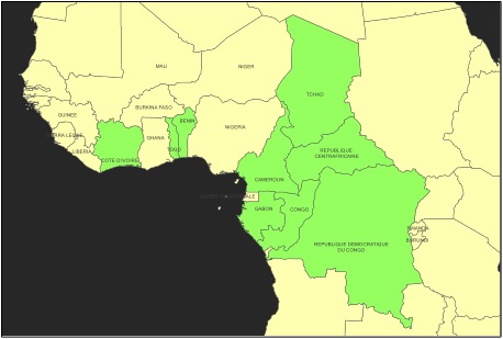
Interesting at the conference, was the time of revelations of the different projects. Each country counting a maximum of 3 presentations; drawn from Ivory Coast, Cameroon, Chad, Central African Republic, DR Congo, Congo Brazzaville, Gabon, Benin, and Togo and from the European commission. While Ivory Coast, DR Congo, and Central African Republic, presented political conflicts, carbon energy and industrial expansion as a major causes for rapid deforestation, the rest of the nations point fingers at Agriculture, demographic pressure, urbanization, wildfire, mining and petroleum exploitation and transhumance as their own reasons for the loss.
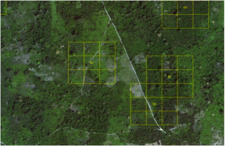
But experts of the European Commission Joint Research Centre, think palm oil big industrial expansion are the biggest causes for deforestation, which always figure in their satellite observations. Mr. Hugh Eva representing the ReCaREDD project financed by the European Commission says “most of the observations show forest partially or fully replaced by palm forest”. Image of Satellite SPOT analyses by square kilometers of the Congo Basin rainforest carried by the European Commission
Logging is another major driver of forest degradation and deforestation. Meanwhile, Ivory Coast, Cameroon, Gabon, Central African Republic and DR Congo significantly earn important revenues from timber sales to make up their GDP. For Example Sales of Timber now contributes around six percent of Cameroon’s GDP. Furthermore, logging roads, paths and camps are creating new avenues for agricultural expansion and poaching which encourage forest degradation. This situation was observed in Chad where “in 10 years from 2000 to 2010 the forest which initially covered a surface area of 1 124 633 ha in the year 2000, lost 50% of its surface area in 2010, because of the aforementioned factors”. The satellite observers of the National Research Support Center at the University of N’Djamena research conducted on the Chadian Oriental forest, revealed. In addition, Mr. Ouya Bondoro, researcher from the University of N’Djamena, disclosing the facts said, “most plants are beginning to dwarf up or adapt to hash climate of the zone”
Describing how important is the observation exercise, giving deeper insight into capacity building examples stake holders of West and Central Africa can follow, Dr. John Fonweban Forest Expert (MRV) from the UN REED Programme of the African Regional Office of FAO, Ghana, said “ Through National forest monitoring system and National forest reference emission level and/or reference level [FAO], The REDD programmes directly support 21 countries and have an additional 56 partner countries, identified in the south where monitoring capacity building projects are ongoing”. He also recommended few important monitoring online information geospatial tools to participants: Like the “globallometree and OpenForis” apps that permit experts to collect data easily using different types of technologies, even mobile phones.
In effect, drawing the importance of Capacity building and forest monitoring for the future of the Congo Basin Forest, WWF with two presentations showed clearly to participants how, satellite images from Google SPOT and observations, analyzed in 2013 is helping them to better understand how to tackle Deforestation in their Ngoyla Mintom forest block project in Cameroon. In fact, their presentation helped students and experts to better understand how long, but exciting it takes to bring out satellite images and successfully analyze them to bring out concrete results.
By copying the embed code below, you agree to adhere to our republishing guidelines.


